Tuesday, 29 April 2014

Why you should attend Geo: The Big 5, Open Geospatial

There are only two weeks to go until the next Big 5 event Open Geospatial takes place in Northern Ireland 
and it’s definitely time to make a really clear case for why you should attend. I normally consider lists the epitome of lazy writing however in this case I can’t think of a better way to put it so here are 5 (or 6) reasons that we should be seeing you in Belfast on 13 May:

1. Whoever you are, wherever you are Open matters and is not going to go away
I have written about this before but time to restate it quickly. Open Geospatial impacts the whole industry; whether as a provider you are helping implement or competing with open source products or if as a user you are looking to utilise increasing amounts of open data (or as a data owner trying to open up your data). How the challenges and opportunities provided by open are tackled by the industry will have a huge impact in the future. A lack of standards, poor practices and a move back towards restriction could all have significant implications for the role of geospatial over the next 15 years. That is why it is important to get involved in the conversation now.

2. We’ve got a great programme of speakers
Following on from the above point we’ve got a great programme of speakers who will be tackling the pertinent issues in Open Geospatial. These range from high level industry insight and overview such as ‘open public data as a catalyst for innovation’ to more specific detail on topics like linked open data and the need for ‘geomaticians’. The day also includes a panel debate from some of our speakers allowing you to take part in the conversation.

3. Keep up to date with workshops
Need to convince your boss why you should be out of the office? How about a hands on intro to Ordnance Survey’s open data using QGIS or some open source apps from Esri? We know that workshops are always popular and are making sure we include more of them in the Big 5 event series.

4. Be part of a bigger response
This event is part of the wider Geo: The Big 5 series and the conversations that come out of it will be helping to inform the AGI's response to the issues of the day. The need for standards in open, the power and potential of opening up public data, enabling collaborative solutions to problems; these are issues where you can help us form our voice. Many of the discussions from Future Cities are coming up again as we draw up the programme and it is this chance for interlinked thinking that needs to be harnessed to push the value of geospatial forward.

5. Join the conversation (networking)
As always this is a great opportunity to meet with your peers, discuss the issues at hand and meet customers or look for new ones. Networking is a key part of any event and we have networking time afterwards. If you are coming from outside Northern Ireland this is a great opportunity to meet a new GI community.

6. Its only £49!
Finally, it is only £49 for members (including IRLOGI members in the spirit of cooperation), this is really very cheap for a one day conference especially one packed with two streams of great content and workshops making it ludicrously good value.

Also if you’re not from Northern Ireland it’s a great chance to come and see Belfast at the same time as learning something/doing some business. For more information on getting too and staying in a rather excellent city have a look at the logistics pack

Thursday, 24 April 2014

Re-branding, Websites and GeoCom ‘14

I apologise for the sparse blogging over the past couple of weeks but I’ve been rather preoccupied with the three items above (and the other Geo: Big 5 events). The good news is that this work is paying off and we’ve made loads of progress to update people on.

First up is the branding, as many of you may have noticed (especially delegates at Future Cities) we have been working on a new brand. The old AGI brand has served well over the years but has become fragmented and a little dated over time. 

With the work being undertaken on a new AGI website we wanted to ensure that we had a clean and consistent new brand so this combined with the 25th anniversary seemed like the perfect opportunity to undertake a rebranding exercise.

 More information can be found here but we feel the new brand gives a very clear visual statement that the AGI wants to make sure that it is doing all it can to be relevant in 2014 and beyond. The new brand is much more than just a logo and will reflect how we communicate within and beyond our industry going forwards and builds on a lot of work that is being done behind the scenes as to who we are and what we stand for.

We have created a page with the various brand resources on which can be found here.

Next up and probably most exciting for most of you is the work being done on a new website. Our current website is a little dated to say the least and places a lot of limits on what we can do so the decision has been taken that rather than attempt to re-skin and tinker with it we are going for a whole new site. 

I am lucky enough to be one of the small group working with the developers on the new site and I can already say it is going to be a vast improvement. We want the site and the member’s area to become a content and knowledge hub for the industry and will be populating it with news, features, interviews and content from passed events among other things.

As always the success of this will depend on our members and we will be making it accessible for SIGs and other groups to edit and add content that is interesting to them. We welcome comments from members on what content they might like to see and also if there is anything they would like to contribute. The new site is expected to go live in late June but in the meantime we have launched an interim site just for Geo: The Big 5.

Finally we come to GeoCom – ‘The Changing Face of Geo’, the change in name partly reflects a desire to move from an inward looking community to an outward looking group engaging with wider industry and partly because everyone just shortened it to GeoCom anyway. We visited the venue at the start of April and it is fantastic and a very different space to the EMCC. Not only is it a very nice looking country hotel but it also has an awful lot of different meeting rooms. This is going to enable us to run a lot more workshops and hands on training sessions (as the majority of delegates have requested). As a result we’re going to be delivering a GeoCom that is a lot more varied than last year with the core focus being on getting really good content and speakers.

Anyway more on GeoCom will follow as we finalise the programme and the speakers but in the meantime have a look at the new brand and think about what you might want to see on the new website.

Friday, 11 April 2014

Sponsor Feedback and GeoCom '14 - David Henderson

David Henderson the AGI Vice Chair has kindly provided me with a brief report of our visit to the fantastic new GeoCom venue last week:

Along with the AGI Team and some fellow Council Members, last Thursday I attended a meeting of AGI Suppliers SIG at the Chesford Grange Hotel near Warwick where we will hold this year’s GeoComm conference on the 11-13 November. 

The meeting allowed some of our corporate members – 1Spatial, Dotted Eyes/MISO, GGP systems, Sterling Geo and Ordnance Survey – to give some further feedback to the AGI events team (this year chaired by Rollo Home) and for us to have a tour of the conference facilities.

Whilst the move away from Nottingham will bring some inevitable changes to the look and feel of our annual conference, I am really excited by the fresh new opportunities that Chesford Grange Hotel will afford to the event – the food was quite tasty too!!

At AGI we’re really excited about how our 2014 events programme has begun. You can read more about the fantastic success of our first event, hosted by AGI Scotland national group, in Glasgow last month. Members travelled from across UK to participate in some very high quality discussion and debate.  Our events programme complete with new branding and sponsorship opportunities can be found here.

We’re delighted that both ESRI(UK) and Ordnance Survey have committed to Diamond Sponsorship for 2014 and equally pleased to have agreed event sponsorship packages with so many of our other corporate members. Our 2014 event programme in particular has been developed in conjunction with our Suppliers SIG and is giving an important platform for the geographic information industry to discuss many of the big issues that are impacting and presenting opportunity for our members. Plans for 2015 have already started. If you’d like to get involved in any of our events or discuss sponsorship then the AGI Team or any member AGI Council would love to hear from you.

In the meantime, we look forward to seeing as many of our members as possible at the next Big 5 event in Belfast on 13 May.

Wednesday, 9 April 2014

Open Geospatial and why we should care

The next Geo: The Big 5 event, Open Geospatial in Belfast is approaching fast. I am not going to launch into a lengthy debate about Open Source vs Proprietary GIS systems or similar. This has been done to death and by people much better placed to talk about it than me.

What I will say is that this event is about much more than open source software and has a relevance to all producers and consumers of geospatial information. The full programme will be released soon but some of the highlights among the speakers include Denise McKenzie from OGC,  Eoin McFadden from DETI NI and Dr Tracy Lauriat from NIRSA (National Institute for Regional and Spatial Analytics) who is highly regarded for her work with open data in Canada.

Following on from the Future Cities event the increasing opening up of data and the innovation and benefit this can bring to both the public and private sectors look to be a key themes. Whilst increasing use of open data seems on the face of it to be more of a benefit to the public sector in enabling joined up thinking and better decision making this is of course a huge opportunity for companies to sell their expertise and help various authorities and departments make the most of their data.

The less glamorous but vitally important cousin of open data is open standards. We were recently lucky enough to have a presentation from the AGI Standards Committee in a recent council meeting and for someone who has always seen standards as rather dry this was a real eye opener. If as an industry and a society we are to benefit from the increasing availability of data we need to ensure data standards are applied and followed in as universal a way as possible. It would be a great shame to find that one local authority was making data available in a format that was incompatible with other authorities’ data or to find that a contractor was collecting data that didn’t match up with their other data sets (an all too common occurrence in the private sector). We want to ensure that open data is a methodology to break down silos not just create a whole host of new ones. Again this is likely to be very much on the agenda particularly the panel debate, with the conversation following on from an Open Standards event the AGI is holding in London the day before.

Open is important whoever you are in geospatial. If you’re a user of geographic information then come along and see how you can be getting the most from opening up your data and if you’re a supplier or consultant then you should be exhibiting and showing of how you can help the clients make the most of their data (and accumulate more and more relevant data).

You can book for the event here; it’s only £49+VAT for AGI members (which is very cheap really). Remember these are UK wide issues and Belfast is only a short flight from most major UK cities and it’s on a Tuesday so you can tack it on to a holiday, explore Northern Ireland and make a long weekend of it.

For our corporate members this is a great opportunity to get your expertise with open in front of an increasingly geo savvy public sector from across Northern Ireland and the Republic. You can view and book sponsorship options or email chris.rhodes@agi.org.uk

Tuesday, 25 March 2014

Geo: The Big 5 - Future Cities Story

As promised here is the Future Cities side of the Geo Big 5 write up. The content was kindly provided by our events group manager Rollo Home, I have done some reordering so any comprehension issues are probably my fault.

Glasgow Future Cities Team
The event was opened with a short but well aimed introduction from Councillor Gordon Matheson (leader, Glasgow City Council) who congratulated the AGI on reaching 25yrs "and looking good on it". He stressed the council’s commitment to opening up their data to public access through the portal where 85 data sets are currently published (including planning applications) including data from Ordnance Survey and the MET office. The focus is very much on putting the data into the hands of the citizen, as seen in the example of the customised city dash-board. The Councillor was keen to stress that while technology is great it is simply an enabler and it is the approach and political will that is the key. Glasgow have a clear desire to be a global reference point for future cities.


Andrew Collinge (Assistant Director, Greater London Authority) gave the first key note for the day, and started by outlining how “City Thinking” was now en vogue and thus he’d stress that it wasn’t the case of London vs. UK as currently being portrayed in the media, but “a Tale of, well, lots of cities” each emerging. However London is large, with a population that will exceed New York’s by 2016. Like Glasgow, London has embraced open data, and the portal drives 20% of traffic to the Council site. He then went on to give an example of some of the challenges London faces: 400K new jobs are needed, 40K new homes will required and 4,000 extra classrooms. One practical solution that the Future Cities approach has provided has been the School Atlas that allows authorities across London to see classroom provision and demand and plan accordingly, in the spirit of open data this is a public facing site.
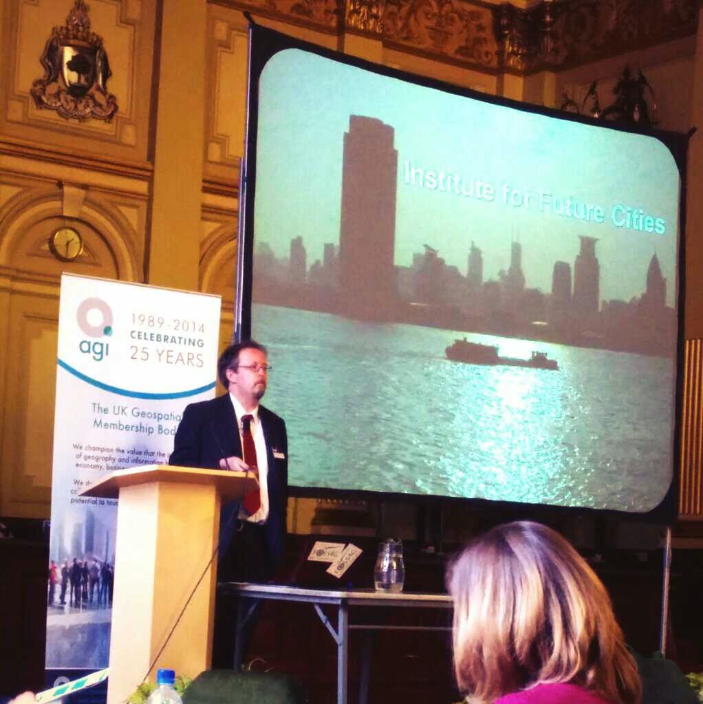
Institute of Future Cities
An interesting point made was that these problems have not just be realised – the concept of Future Cities was identified by 50 urban scientists meeting in 1960's US and outlining the issues of 'regeneration of cities needed to keep pace of demand’.

The plenary led into the Future Cities Steam which was chaired by Graham Colclough. A surprising thing about these sessions was the strength of continuity of the message between speakers. There was limited disagreement about the scope and scale of the problems being addressed by the Future Cities concept nor, the fact that location based data had an important role to play in tackling these problems. What was perhaps more surprising was that the focus of the discussions was entirely on the value of using geospatial thus we did not hear about how an application was developed and deployed, but about the reasons that they were developed, the success of the uptake, and the outcomes.

Steven Revill (Future Cities Glasgow) started the Future Cities session with a fuller review of the work already referenced by Councillor Matheson. The Open data market to “empower Glasgow” was a prominent thread of the discussion. This was achieved through the web portals and out outlets such as the My Glasgow Apps. In regard to adoption of the services, Steven reflected on how useful the branding had been to engage to younger audience, as was the premise of presenting data stories. The platform itself is developed quickly with releases often made in an attempt to maintain momentum to the project. The search for new data is on-going with GCC energy consumption of all public sector and education buildings being the latest. This has enable people to scrutinise energy use putting buildings that use excessive energy in the public eye and driving change

A question from the floor raised the issue of data quality. Apparently operational data from GCC is good, but there is discrepancy and an issue with completeness. However publishing the data is helping address and potentially resolving this problem. Making it public is driving a change in behaviours.

Dr Diarmad Campbell (British Geological Survey) had a very different focus, and that is the sub-surface. BGS have an Urban Strategy for the simple reason that 80% of the population live in such areas, and therefore the activity that requires geological analysis (structures) is concentrated in these areas. While internationally other cities such as Oslo and Amsterdam have huge investment in understanding the underground, in the UK there has not been such a history of investment. BGS are now working with GCC to produce a complete and detailed model of the sub-surface. Many urban areas, not least Glasgow have a complex sub surface environment from legacy industry as well as industrial processes and BGS are driving towards multi channel data availability to allow for better provision and better decision making.

George Kirk from Scottish Power Energy Networks discussed integrated energy planning, that is dealing with power from station to the plug. He explained how low carbon is a key part of Glasgow City development but has so far no being tackled fully. Previously there has been no shortage of data, but a limited understanding of how we use that data to make decision. Now there is an opportunity to inform the profession and public alike through visualisation and data availability

The afternoon session moved the focus of the discussion from Glasgow and the UK to the global context, and this was kicked off by Richard Bellingham (Institute for Future Cities, Strathclyde University) by presenting the issues of the changing world and in particular a growing and aging urban population. These are challenges that cities have no control over but cities are required to respond to them.

The scale of the problem is immense, billions of people moving to cities in the coming decades – which are creating patterns of mega-cities across the world. However we have to consider that this migration is a voluntary process. Cities are desirable places to live. They also act as engines for economic development and offer a solution to our energy crisis in that they are also more efficient per head on almost every measure.
Teresa and the Future Cities Catapult

Finally Teresa Rico Gonzales (Future Cities Catapult) rounded the session off with the work that the TSB is funding through the Catapult in order to mitigate the vast challenge of rural to urban migration. However she was keen to stress that the FCC is not reinventing the wheel but looking to utilise the expertise that is out there and enable collaborative creation of the solutions, a common them across the afternoon’s speakers.

The motivations of the FCC are focused on particular outcomes; the primary is a duty of care (as a remit of the TSB funding), but other more tangible (and commercial) targets are related to generating exportable urban innovations, growing UK market share of the global Future Cities potential and to build a world-class urban cluster.

The session was rounded up with a panel discussion led by Graham Colclough with:

The Panel
Richard, Teresa, Diarmad, Steven and Rollo Home on the stand. Graham encapsulated the discussion as revolving around two basic principles of information/data and collaboration which was re-iterated by the panel speakers, but each presented their own perspective on the problem with the Ordnance Survey and BGS looking at this from the position of having data to offer but needing to work with cities to understand the nature of the requirement, and with cities working with academia to understand the actors driving change and their requirements for data to monitor and support those agents. 

Thursday, 20 March 2014

Geo: The Big 5 gets underway!


Not a bad turnout...
Yesterday AGI Scotland hosted Future Cities the first of the Geo Big 5 events series and I'm pleased to say that we've got off to a flying start. Delegate turnout was at pre recession levels, the speakers were fantastic and the venue was pretty spectacular (thanks to Glasgow City Council for that one). Both streams had a really solid line up of presentations and the panel debate in the afternoon was really well received (those can be tricky to pull off).

I spent the day room monitoring in the best practice stream so I will be getting one of my colleagues to write a summary of that soon. In the meantime this’ll be a brief round up of the sessions I saw which included some great pieces of innovation.

The event opened with some very encouraging comments from the head of Glasgow City Council, showing that the local authority has really understood the power of GI to improve services for the citizen. However I will let my colleague cover this more within the context of the future cities stream.

The Main Room/Palace
The morning best practice stream opened with a presentation from the Forestry Commission Scotland on releasing a Scotland wide dataset on native woodland. This was quite an ambitious project in scope with the whole of Scotland surveyed over a period of about six years (some areas surveyed in greater detail based on aerial imagery). After collecting this huge dataset the team then overcame a number of challenges to provide this as open public data easily accessible to non GI users.

This was followed by a very nice presentation/demonstration from Paul Clarke of Esri on designing the future city. This showed City Engine being used on a range of projects as well as a general view on what future cities may look like. Paul also echoed the councillor’s comments about when talking about future cities it is what we are doing today that will define how they look and work.
The following presentation on the use of GI to support the Commonwealth Games in Glasgow gave a very practical demonstration of the challenges a modern city faces and the tools we have to overcome them.

After lunch the best practice stream kicked off with a really interesting project from Ross McDonald and Angus Council. They had successfully evolved their geospatial offering from a truly Byzantine collection of different platforms, datasets and file types into a much more open focused and integrated set up. This has allowed them to free up powerful but expensive proprietary software for users who most need it whilst spreading the power of spatial much wider across the organisation. Their mantra appropriately is ‘spatial isn’t special, its core’.

A presentation by ERM showcasing the use of GI for environmental and social management of major projects was up next. A particularly interesting feature of this solution is that it is accessible via the web and allows users (such as local residents) to comment on features of a project.

Last but not least Scottish Water and Kemeling Consulting presented on an asset visualisation project they have been working on. This project allows much better visualisation of sections of the Scottish Water network allowing the double benefit of improved repair efficiency and also improved transparency with local communities as to why work is being undertaken. The project has so far informed around £1 million worth of repair work.


An overall theme coming out of this stream, particularly the afternoon sessions was that the next step for cementing the role of spatial is to be able to articulate hard financial savings from projects such as these. All the users know there was benefit and the challenge is to be able to express this financially, something that is particularly crucial as the use of spacial spreads into the private sector.

Friday, 14 March 2014

Geo: Education

I've talked a lot about the Big 5 themes for 2014 and of course there are other contenders for big issues in geospatial. I wanted to look at one that is not so much an issue for geospatial now as one for how geospatial grows in the future and that is education.

The geospatial industry is continually growing and broadening to the point that many people are using and even producing data and products that they don’t really realises is geospatial. To support this the next generation of geospatially literate employees is needed. Obviously now this has spread beyond the traditional GIS user to a whole range of developers, software engineers and analysts amongst others. However this diversification just means that an introduction to geospatial is needed at a younger age than ever rather than waiting until university when people are already specialising heavily. It would be a shame to lose out on potentially brilliant developers because they have no concept of spatial or how important and powerful it can be.

At the Future Cities event in Scotland we are running a parallel session from students attending some local colleges. They will get a chance to talk to some of the great speakers from our event and get an understanding of the broad importance of geospatial information and future cities specifically. This is being held in collaboration with RSGS who are organising a visit to the University of Glasgow map library in the morning.

This is something the AGI wants to get more involved in (possibly through collaboration with RGS and their geography in schools programme as per this announcement a few days ago). We have recently moved to engage more with university level students through opening up free membership and we will be looking to create resources for students with the new website.


 This is an important issue both for education and the industry, at a later date I hope to have an article from one of our council members who has a particular interest in education. In the meantime however I would love to hear suggestions for how the AGI, industry and indeed government can help usher through the next generation of geospatial innovators.